Geography helps us understand the world we live in. One of the key concepts in this field is local relief. Whether you’re hiking in the mountains, studying maps, or planning land development, understanding the concept of local relief is essential. But what exactly is local relief? Why does it matter? And how does it shape the way we view landforms? Let’s dive into these questions in this comprehensive guide.
What is Local Relief?
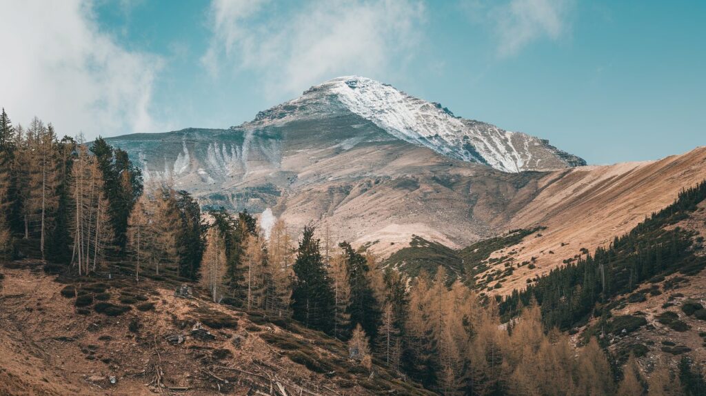
In simple terms, local relief refers to the vertical difference in elevation between the highest and lowest points of a land surface within a specified horizontal distance. Think of a mountain range: the peak is the highest point, and the valley or flat ground at the base is the lowest point. The difference between these two elevations is the local relief.
For example, in an area where the highest peak is 2,000 feet above sea level and the valley is 500 feet, the local relief would be 1,500 feet. It’s an essential metric in geography that helps us understand how rugged or flat an area is.
Local Relief refers to the vertical difference in elevation between the highest and lowest points within a specified horizontal distance on a land surface. In simpler terms, it measures the difference in height between the highest peak and the lowest valley in a particular area.
For example, if a mountain peak stands 2,000 feet above sea level and the nearby valley is 500 feet above sea level, the local relief would be the difference between the two elevations—1,500 feet.
This concept is important in geography because it helps in understanding the shape, ruggedness, and features of the terrain. Local relief can be used to describe a variety of landforms, from flat plains to towering mountain ranges. It is often studied to determine the characteristics of landscapes and landforms and plays a significant role in activities like urban planning, environmental management, and climate studies.
Key Components of Local Relief:
- Elevation: The height of a point above a reference level, usually sea level.
- Highest Point: The peak or the highest elevation within the given area.
- Lowest Point: The base or the lowest elevation within the given area.
- Vertical Difference: The difference in height between the highest and lowest points, which defines the local relief.
Examples:
- Mountainous Regions: High local relief, with large elevation differences between mountain peaks and valleys.
- Flat Plains: Low local relief, with small elevation differences, often appearing flat to the naked eye.
How to Measure Local Relief:
To measure local relief:
- Identify the highest and lowest points within a specific area.
- Use a topographic map or a GPS device to find the elevation of both points.
- Subtract the elevation of the lowest point from the highest point to get the local relief.
For example, if the highest point in an area is 3,000 feet and the lowest point is 500 feet, the local relief is 2,500 feet.
Importance of Local Relief:
- Understanding Terrain: Local relief is used to classify terrain, distinguishing between mountains, hills, valleys, and flat plains.
- Urban Planning: Informs planners on where to build structures and roads. High local relief areas may be difficult and expensive to develop.
- Ecosystems and Wildlife: Local relief influences water flow, vegetation patterns, and animal habitats. Steeper areas may promote faster water movement and erosion, while flatter areas may develop wetlands or marshes.
- Climate: Areas with high local relief, like mountains, often have different weather patterns compared to flatter areas. Mountains may block or channel winds, affecting precipitation and temperature.
Types of Local Relief:
- High Local Relief: Areas with large elevation differences, such as mountain ranges (e.g., the Himalayas or the Rockies).
- Moderate Local Relief: Areas with rolling hills or valleys, like the Appalachian Mountains or the Midwest’s rolling hills.
- Low Local Relief: Flat areas, such as coastal plains or deserts (e.g., the Great Plains or the Sahara Desert).
Differences Between Local and Absolute Relief:
- Local Relief measures the elevation difference within a specific area.
- Absolute Relief refers to the height of a location above sea level.
Summary:
In conclusion, local relief helps geographers, geologists, and planners understand how rugged or flat an area is. It plays a crucial role in determining the physical characteristics of landforms, water flow, climate, and human development. Whether for scientific studies or practical applications like construction and land use, understanding local relief is a fundamental aspect of terrain analysis.
What is an example of a local relief?
An example of local relief can be found in the Grand Canyon, located in Arizona, USA. The Grand Canyon showcases dramatic changes in elevation within a relatively short horizontal distance, making it a perfect example to illustrate local relief.
Grand Canyon: An Example of Local Relief
The Grand Canyon is one of the most iconic landscapes in the world and is known for its significant local relief. It is a steep-sided canyon carved by the Colorado River, exposing nearly 2 billion years of geological history.
Understanding Local Relief in the Grand Canyon:
- Highest Point (Rim): The elevation at the top of the Grand Canyon, called the “rim,” can be around 7,000 feet (2,134 meters) above sea level on the North Rim and 6,800 feet (2,072 meters) on the South Rim.
- Lowest Point (Colorado River): At the bottom of the canyon, the Colorado River flows at approximately 2,200 feet (670 meters) above sea level.
- Local Relief: The vertical difference between the canyon rim and the river is around 5,000 feet (1,524 meters) in some areas. This means the local relief of the Grand Canyon can reach as high as 5,000 feet, which reflects the tremendous depth and ruggedness of the landscape.
This 5,000-foot difference between the highest point on the rim and the lowest point by the river makes the Grand Canyon a classic example of a region with high local relief.
How to Measure Local Relief in the Grand Canyon:
To calculate the local relief of the Grand Canyon:
- Identify the highest point: The rim of the canyon is around 7,000 feet (North Rim).
- Identify the lowest point: The Colorado River at the bottom is around 2,200 feet.
- Subtract the lowest point from the highest point:
- 7,000 feet (rim) – 2,200 feet (river) = 4,800 feet of local relief.
This difference in elevation illustrates the steep drop from the rim to the river, showing how rugged and deep the canyon is.
Importance of Local Relief in the Grand Canyon:
- Geological Understanding: The Grand Canyon’s high local relief exposes layers of rock that provide valuable insights into Earth’s geological history. Different strata of rock, including limestone, sandstone, and shale, can be studied thanks to the high elevation differences.
- Tourism and Recreation: Visitors to the Grand Canyon come to experience its sheer size and depth, which are a direct result of its high local relief. Activities such as hiking from the rim to the river, or viewing the landscape from observation points, are influenced by the canyon’s dramatic elevation changes.
- Ecosystem Diversity: The local relief in the Grand Canyon creates a variety of microclimates and ecosystems. The North Rim, for example, is cooler and more forested due to its higher elevation, while the canyon floor is much hotter and more arid. This range in elevation supports diverse plant and animal species.
- Impact on Weather: High local relief in the Grand Canyon affects weather patterns. The rim, being higher in elevation, can be much cooler than the canyon floor, where temperatures soar. This difference creates distinct weather patterns that vary greatly within the canyon itself.
Comparison to Other Examples of Local Relief:
| Location | Highest Point | Lowest Point | Local Relief |
|---|---|---|---|
| Grand Canyon, USA | North Rim (7,000 feet) | Colorado River (2,200 feet) | 4,800-5,000 feet |
| Rocky Mountains, USA | Mount Elbert (14,439 feet) | Adjacent valleys (5,000 feet) | 9,439 feet |
| Great Plains, USA | Varies (up to 6,000 feet) | Low plains (~1,000 feet) | Typically around 5,000 feet |
| Appalachian Mountains | Mount Mitchell (6,684 feet) | Nearby valleys (2,000 feet) | 4,684 feet |
| Death Valley, USA | Telescope Peak (11,043 feet) | Badwater Basin (-282 feet) | 11,325 feet |
Additional Examples of Local Relief:
- Himalayas: The local relief in the Himalayas is extreme. For example, Mount Everest (the world’s tallest peak) has an elevation of 29,032 feet (8,848 meters), and nearby valleys can be as low as 4,000 feet (1,200 meters), giving it a local relief of over 25,000 feet (7,600 meters) in some areas.
- Rocky Mountains: In Colorado, the highest peak, Mount Elbert, stands at 14,439 feet (4,401 meters) above sea level. Nearby valleys can be as low as 5,000 feet (1,524 meters), giving the area a local relief of about 9,000 feet (2,743 meters).
- Appalachian Mountains: The Appalachians have a more moderate local relief compared to other mountain ranges. Mount Mitchell (the highest peak in the eastern U.S.) reaches 6,684 feet (2,037 meters), and nearby valleys may be around 2,000 feet (609 meters), making the local relief around 4,600 feet (1,400 meters).
Why is Local Relief Important in the Grand Canyon?
- Tourism and Exploration: The sheer depth and steepness of the Grand Canyon’s local relief attract millions of tourists yearly for hiking, rafting, and sightseeing.
- Environmental Impact: The high local relief impacts erosion rates, soil formation, and water drainage patterns, playing a crucial role in the Colorado River’s ability to continue carving the canyon over millions of years.
- Biodiversity: The local relief creates varied habitats at different elevations, supporting a wide range of flora and fauna, from desert cacti at the bottom to pine forests on the rim.
- Geological Insight: The deep vertical cut of the canyon provides a unique view of Earth’s geological history, with rock layers exposed over a span of almost two billion years.
Summary:
In summary, the Grand Canyon is an excellent example of local relief because of its dramatic elevation differences between the rim and the river below. This vertical variation shapes the landform, ecosystem, and human activities in the region, making it a critical case study for understanding local relief in geography.
Importance of Local Relief in Geography
Why should you care about local relief? The concept is vital for several reasons, especially in fields like topography, geology, and urban planning.
1. Understanding Landforms
When you look at a map, local relief helps you determine the terrain. Are you dealing with mountains, hills, or flat plains? Higher local relief usually means more rugged terrain (think of the Rocky Mountains), while lower local relief signifies flatlands (like the Great Plains).
2. Influencing Climate and Weather
The vertical elevation difference in a region can impact the climate. Areas with high local relief, such as mountainous regions, may experience more rainfall, cooler temperatures, and other weather variations. Local relief affects air circulation and precipitation patterns, making it a key factor in climate studies.
3. Aiding in Urban Planning
For engineers and urban planners, understanding local relief is crucial. It helps determine where to build roads, bridges, and buildings. Steep terrains with high local relief might be more challenging and expensive to develop than flatter areas with low relief.
Types of Local Relief
Local relief can vary dramatically depending on the region. Below are some of the common types of local relief:
1. Mountainous Relief
Areas with steep slopes, high peaks, and deep valleys. Examples include the Himalayas and the Rocky Mountains.
2. Hilly Relief
Regions with gentle slopes and rounded hills. These areas have moderate local relief, like the rolling hills of Kentucky.
3. Flat Relief
This type of relief is found in regions with little to no elevation difference, like the Great Plains or coastal plains.
4. Coastal Relief
Found along shorelines, this type of relief can vary from high cliffs (like those in California) to flat, sandy beaches (like those in Florida).
| Type of Local Relief | Examples | Characteristics |
|---|---|---|
| Mountainous Relief | Rocky Mountains, Himalayas | High peaks, steep slopes, deep valleys |
| Hilly Relief | Kentucky, Appalachians | Moderate slopes, rolling hills |
| Flat Relief | Great Plains, Florida | Low elevation differences |
| Coastal Relief | California cliffs, Florida beaches | Shorelines with varied elevations |
How to Measure Local Relief
Measuring local relief is relatively simple but requires the right tools. Here are a few steps:
- Select the Area to Measure: Identify the highest and lowest points within the area you’re interested in.
- Use a Topographic Map: Topographic maps show elevation changes through contour lines.
- Calculate the Difference: Subtract the elevation of the lowest point from the highest point.
For example, if the highest point is 2,500 feet and the lowest point is 800 feet, the local relief is 1,700 feet.
Tools to Measure Local Relief:
- Topographic Maps: These maps show elevation changes through contour lines.
- GPS Devices: Modern GPS devices can measure elevation and track points.
- Elevation Apps: Apps like PeakFinder or Gaia GPS help measure the relief of an area.
| Method | Description |
|---|---|
| Topographic Maps | Maps with contour lines that represent elevation changes |
| GPS Devices | Devices that track exact elevation at different points |
| Elevation Apps | Apps that provide detailed elevation data using satellite |
Local Relief vs. Absolute Relief
It’s important to differentiate between local relief and absolute relief. While local relief focuses on the difference in elevation within a specified area, absolute relief measures the total elevation above sea level.
For instance, Mount Everest’s absolute relief is over 29,000 feet because that’s its total elevation above sea level. But the local relief of Mount Everest would be the difference between its peak and the nearby valleys.
How Local Relief Shapes the Environment
The concept of local relief has practical implications on both natural and human-made environments:
1. Ecosystems and Vegetation
Regions with high local relief often support a diverse range of ecosystems. The varied elevations create microclimates that can support different types of vegetation and wildlife.
2. Water Flow and Erosion
Local relief influences how water moves through an area. High local relief leads to faster-moving streams and rivers, which can result in increased erosion. On the other hand, low-relief areas might experience slower water movement, leading to marshes or wetlands.
Key Takeaways:
- Local relief is the vertical difference in elevation between the highest and lowest points within a specific horizontal distance.
- It plays a crucial role in understanding landforms, climate, and urban planning.
- There are different types of local relief, such as mountainous, hilly, flat, and coastal relief.
- Measuring local relief is simple and can be done using tools like topographic maps or GPS devices.
- It is different from absolute relief, which measures total elevation above sea level.
Important Point
| NO. | Important Points |
| 1. | About Us |
| 2. | Contact Us |
| 3. | Disclaimer |
| 4. | Privacy Policy |
FAQs of Local Relief
What is local relief in geography?
Local relief is the vertical difference in elevation between the highest and lowest points of a land surface within a specified horizontal distance.
Why is local relief important?
Local relief is important because it helps us understand terrain, influences climate, and aids in urban planning.
How do you calculate local relief?
To calculate local relief, subtract the elevation of the lowest point from the highest point in a given area.
What is the difference between local relief and absolute relief?
Local relief measures the elevation difference within a specific area, while absolute relief measures the total elevation above sea level.
What tools can I use to measure local relief?
Tools like topographic maps, GPS devices, and elevation apps are commonly used to measure local relief.
What is an example of high local relief?
An example of high local relief is the Grand Canyon, which has a significant elevation difference between its highest points and the Colorado River below.
How does local relief affect weather?
Areas with high local relief, such as mountains, can have more precipitation and cooler temperatures due to elevation changes.
What type of areas have low local relief?
Flatlands, like the Great Plains, typically have low local relief.
Can local relief impact construction?
Yes, high local relief can make construction more challenging, while low-relief areas are generally easier to develop.
Is local relief a key factor in landform development?
Absolutely. Local relief plays a significant role in shaping landforms and determining water flow patterns.
See these too
- Read Also: Understanding Lithology: The Key to Rock Descriptions
- Read Also: Understanding Limestone: Formation, Composition, and Importance in Geology